


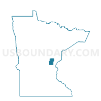
Braham Voting District, Kanabec County, Minnesota
About
Outline

Summary
| Unique Area Identifier | 602689 |
| Name | Braham Voting District |
| County | Kanabec County |
| State | Minnesota |
| Area (square miles) | 0.09 |
| Land Area (square miles) | 0.09 |
| Water Area (square miles) | 0.00 |
| % of Land Area | 100.00 |
| % of Water Area | 0.00 |
| Latitude of the Internal Point | 45.73294880 |
| Longtitude of the Internal Point | -93.17131480 |
Maps


Graphs
Select a template below for downloading or customizing gragh for Braham Voting District, Kanabec County, Minnesota


Neighbors
Neighoring Voting District (by Name) Neighboring Voting District on the Map
- Braham City Voting District, Isanti County, MN
- Grass Lake Twp. Voting District, Kanabec County, MN
- Stanchfield Twp. Voting District, Isanti County, MN
Top 10 Neighboring County Subdivision (by Population) Neighboring County Subdivision on the Map
- Braham city, Isanti County, MN (1,793)
- Stanchfield township, Isanti County, MN (1,209)
- Grass Lake township, Kanabec County, MN (1,038)
- Braham city, Kanabec County, MN (0)